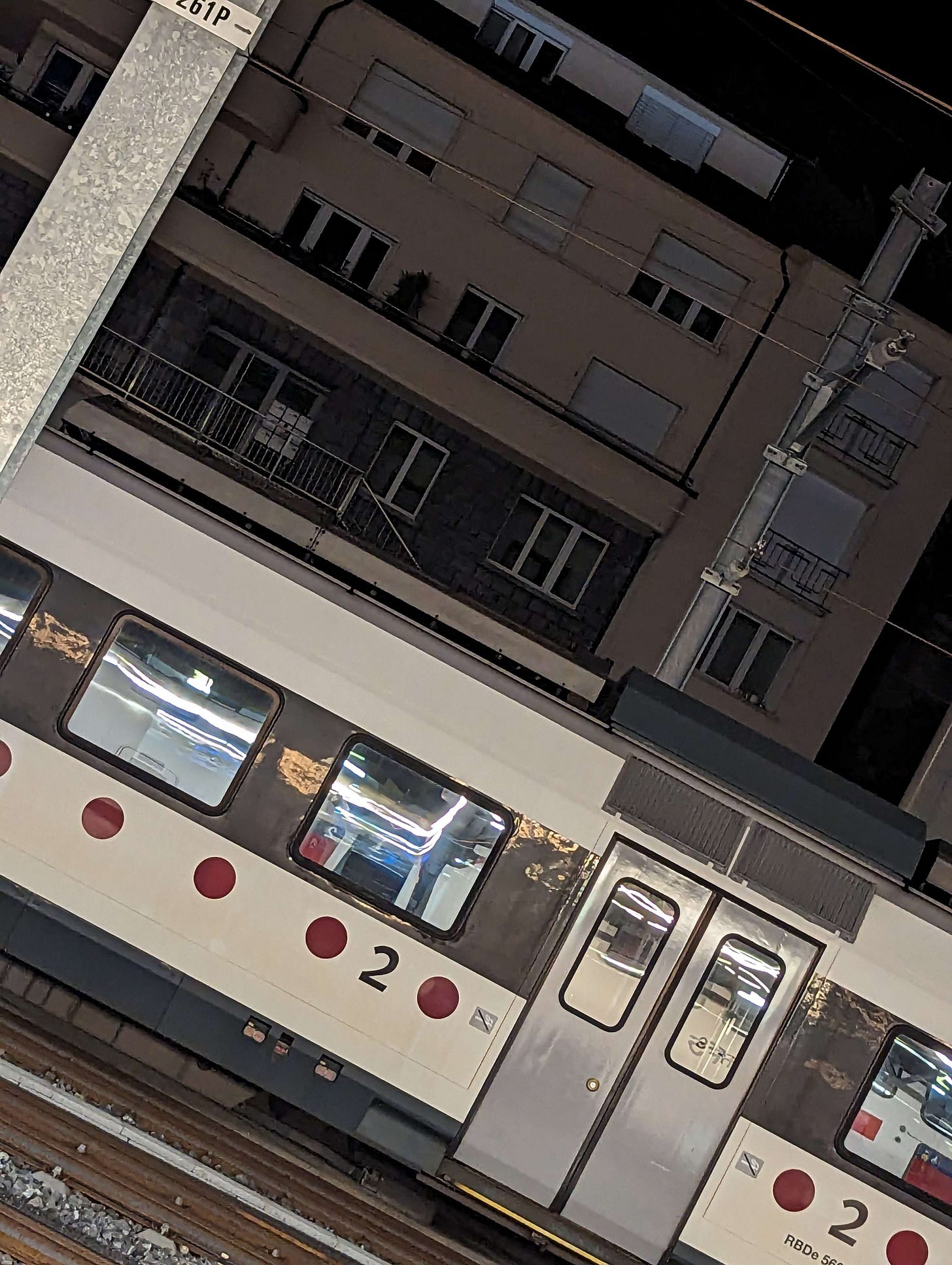
geolocation challenge: a swiss train
this writeup was written in parallel with another on the same geolocation by my friend annie. it’s great, give it a read too!
yesterday night, my friend maia posted a geolocation challenge in a discord server we share. the photo it posted is below—i’ll give you a chance to solve it yourself, though you should read until the first bolded header to get some important information while still avoiding spoilers.
some important context:
maia’s swiss and politically locked within the borders of the country
the filename of its photo was
PXL_20230917_012607611.jpgno useful information is contained within the file of the photo itself (e.g. geotag data)
now’s your chance to give the challenge a shot!
observations
at least three sets of tracks separate maia and the train
the train is on the last track with a wall behind it
a support pole is labeled with the maintenance code
261Pthree sets of overhead wires and a utility pole supporting them are visible
the train has the text
RBDe 56visiblethe rounded top of a third number after the
56is also visibletwo houses in the back are clearly visible
extrapolation and investigation
maia’s almost certainly inside a train station. three to four tracks running next to each other would not be abnormal between stations, as would overhead wires and a utility pole, but most of that interstation area is rural; urban or suburban photos will likely be close to or inside of a station. the maintenance code 261P is also one that could appear on an in-station pole.
most interesting, however, was the text visible on the train. a google search made clear the train was one from the RBDe 56x line, the only ones with RBDe in their name. it contains 9 models:
SBB RBDe 560 (with various local color scheme variations)
SBB RBDe 561
SBB RBDe 562
BLS RBDe 565
MThB RBDe 566
SOB RBDe 566
BLS RBDe 566-II
PBr RBDe 568
it’s easy, however, to rule a lot of these out. for one, the SBB 561, SBB 562, SBB 565, and BLS 566-II are no longer in use. and some models (the SOB 566 and PBr 568) use a single color scheme that doesn’t align with the photo, while other models (the MThB 566) only have service outside of switzerland. this leaves the TPF-TRN 567 and SBB 560 to look at.
the TPF-TRN model uses two color schemes, one all-red (“TRN paint”) and one white with red dots (“TPF paint”), and the latter of the two matches the design and even font of the train in maia’s photo:
but the windows lack a black stripe across them, and i could not find a 567 model with such a stripe. this leaves the SBB 560, which can also appear with TPF paint, and this time there is a black stripe:
one can further confirm the classification by looking at the rounded top of the last letter in the text, which allows for a 0 as the last character:
my next step was figuring out where the trains run. the TPF has webpages giving specifications for their whole fleet, including our RBDe 560. other than giving the train numbers, however, it doesn’t give the lines they’re used for. a bit of research into the individual numbers resulted in me finding this passage from german wikipedia, citing an article in the Schweizer Eisenbahn-Revue (“Swiss Railway Review”), which includes all of the numbers on the TPF webpage:
2021 kauften die TPF für den Betrieb der Durchmesserlinien S20/21 des RER Fribourg/Freiburg von den SBB 11 drei- und vierteilige Domino-Züge RBDe 560 235–243, 245 und 247.
In 2021, the TPF purchased 11 three- and four-car Domino trains of the models RBDe 560 235–243, 245, and 247 from the SBB for the operation of the RER Fribourg/Freiburg S20/21 through routes.
after the publication of this article, two trains were purchased by TPF from the SBB, numbers 244 and 269. they are unimportant, though the RE2 line model 269 runs on coincidentally hits many of the same stations as below.
the S20 is an hourly service that serves three legs: Neuchâtel to Ins (on the Bern–Neuchâtel), then Ins to Fribourg (on the Fribourg–Ins), and finally Fribourg to Romont (on the Lausanne–Bern). the S21 is a similar hourly service, offset 30 minutes from the S20, that operates the latter two legs (from Ins to Romont).
here, we can line up the timetables for the S20 and S21 (they’re split in two, from Neuchâtel to Fribourg and from Fribourg to Romont) with the time the photo was taken. while discord doesn’t preserve EXIF data, it does preserve the google pixel filename PXL_20230917_012607611.jpg, which gives this datetime (2023-09-17 at 01:26:07.611 UTC, or 3:26 Swiss time). and:
it’s a match at Fribourg, on the S21, coming from Neuchâtel and arriving at 01:19, then sitting for 3 hours until its first morning run. being on the track closest to the wall and coming from the north, the S21 must be on track 8 or 9:
pinpointing and verification
it’s safe to say the photo was taken from somewhere on the platform between tracks 4 and 5 in the above photo, looking northwest towards Rue Louis-d'Affry. google earth has this set of houses:
the best candidate is the residential building on the far right. the roof color and body color generally match, and it appears to have similar height and window locations:
street view from 2014 shows the residential building in more detail, confirming a match of the railing, stairs, and general house orientation:
and a 2017 photosphere truly confirms the geolocation, showing a potted plant on the second-floor balcony and array of posters in the lower door:
the photo was taken at (46.80288906, 7.15027627).
you can contact me on twitter (@RhinozzCode) and matrix (@rhinozz:matrix.org).


